For WaveSense the Route to Better Autonomous Vehicle Maps is Underground
Ground-penetrating radar lets autonomous vehicles follow maps that don't change with weather, seasons, or road work.
|
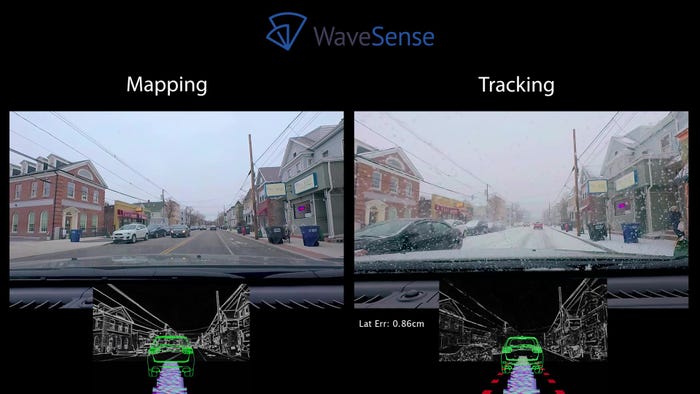
WaveSense ground-penetrating radar tracks the topography 10 feet below the road surface to follow unchanging features that provide maximum accuracy and reliability. (Image source: WaveSense) |
Ground-penetrating radar is typically mounted to a lawnmower-looking trolley and is used to locate objects up to 10 feet beneath the surface of the Earth. It's had some high-profile successes, such as helping to find the remains of England’s King Henry I and King Richard III in recent years.
Boston-area startup WaveSense says it can apply this technology to develop the kind of precise, reliable maps that autonomous vehicles will need to operate safely.
Non-military-grade GPS has erratic accuracy, depending on interference from buildings and other obstacles that block the view of satellites. And the problem with regular radar, LiDAR, and video cameras is that they observe surface features, which can be non-distinguishable or change with time. “It is impossible to do well from an automotive safety perspective, because the surface is dynamic,” noted WaveSense CEO Tarik Bolat. There is changing foliage on the trees, or cars parked along the street or not parked along the street,” he said. And that doesn’t even consider changeable weather, like snow, or obscured or faded lane marking lines.
“On highways there often aren’t sufficient roadside features, or for parking, you have parking lots with undifferentiated features.” The endless rows of columns on identical-looking levels of a parking structure make everything look the same, he added.
By mapping the subsurface, WaveSense can produce virtually unchanging maps, so that autonomous vehicles equipped with their own ground-penetrating radar units can compare what they are seeing with those maps to locate their position precisely.
RELATED ARTICLES:
WaveSense's ground-penetrating radar peers into the ground to see the unique array of soil types, soil densities, rocks, roots, and other things in order to create a map that would be otherwise invisible and provides accurate location information. “You’re doing frame matching as you would with a camera, but with a camera the environment is not stable,” Bolat said. WaveSense does 126 sweeps of the subterranean landscape every second, ensuring a constant stream of data on the car’s location.
By comparison, “the current set of sensors are not reliable enough to deploy production-level autonomous vehicles and certain autonomous features,” Bolat stated.
|
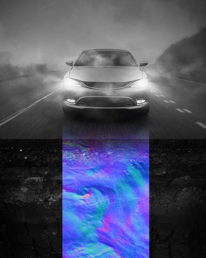
While conditions on the road surface can change between mapping and when customers are tracking their route along the map, the underground topology remains reliably unchanged. (Image source: WaveSense) |
WaveSense would not replace those current sensors, but would instead augment them. It could, at least, reduce the number of LiDAR units installed on future robo-taxis, but would not eliminate the need for LiDAR because it is still important for the car to see what is around it.
A nice aspect of having underground sensors added to the mix is that ground-penetrating radar looks at things that aren’t connected to above-ground objects, so if for some reason it is not able to contribute to the car’s ability to navigate, the autonomous vehicle’s other senses should be undiminished, Bolat pointed out.
WaveSense’s technology was developed by MIT’s Lincoln Laboratory for military applications and the company has an exclusive license for commercial applications. The company is in development with several OEMs and Tier 1 suppliers, with the expectation of products reaching market in 2023 or 2024.
While the product is being developed and validated for commercial use, WaveSense is industriously mapping beneath the streets of major metropolitan areas, interstate highways, and parking lots, so that the necessary database will be in place by the time WaveSense-equipped cars reach the market, according to Bolat. The company is talking to fleet vehicle operators to install map-generating radars on their vehicles to cover as much ground as possible, as quickly as possible.
|
Bad weather has no effect on WaveSense map tracking. (Image source: WaveSense) |
So far, Boston and the Detroit are the company’s best-mapped areas.
On production models, the WaveSense radar unit will be mounted on the vehicle’s bottom in a protected area that has available space. That means the exact location will vary depending on the vehicle’s drivetrain type, but in any case, it will be well protected from damage. And, unlike cameras and LiDARs, it doesn’t need to be kept clean to work effectively.
Bolat says that the bill of materials for the unit that would go into cars is currently about $100, and the industry normally cuts costs as production volume rises. That is a big number for new car program managers, but in the case of autonomous models the cost could be more negligible considering the high costs of so many other systems.
Additionally, these are the kinds of costs that consumers are increasingly willing to bear, Bolat pointed out. “Consumers are making buying decisions based on technical capabilities."
Dan Carney is a Design News senior editor, covering automotive technology, engineering and design, especially emerging electric vehicle and autonomous technologies.
About the Author(s)
You May Also Like


.jpg?width=300&auto=webp&quality=80&disable=upscale)

